
Forts of the Great Plains
The Great Plains was the location of many Army posts because of the resistance of several Plains tribes to settlement, railroad construction, and transport roads that disturbed the bison herds, destroyed the grasslands that their horses and wild game depended upon, and crowded them into smaller areas where they faced more competition for the resources they needed for survival. Posts were built or decommissioned depending on the need for military control of the region.
The Great Plains was also one of the last regions of the United States to see settlement of farmers and tradesmen leading to the growth of cities. Military posts increased in number during the last quarter of the nineteenth century as the Homestead Act and railroad transportation increased the desirability of the Great Plains for settlers from the states and abroad. Some posts began as small guard outposts that women rarely lived in and then grew to posts with housing for officers and enlisted men, hospitals, and adequate supplies for the support of the men and families who lived there.
Plains Army posts constructed or reconstructed after the Civil War tended to be more comfortable for families depending on the location and the extent of military activity. At some posts, an unused building might have been used as a library, but few posts had a chapel or school. At the most isolated posts, communications with any other post or with families in eastern states was limited to occasional mail transport by soldiers.
Officers' wives could usually live at any post or camp if they insisted on going, and there was some form of housing for them, though some locations were not considered properly suited to a woman. Officers often took their wives to temporary camps where they lived in tents during the summer. Winter quarters generally were maintained at established posts.
The following list covers about one-third of the posts that existed during the last quarter of the 19th century. These are the posts that officers' wives mention in their letters or memoirs. They are listed in alphabetical order.
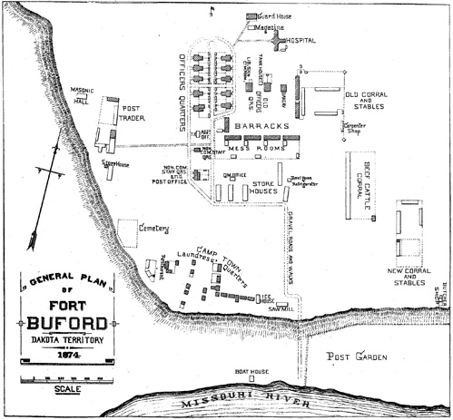
Figure 1. Map of Fort Buford on the western edge of northern Dakota Territory on the Missouri River. Note the road around the sets of Officers' Quarters, the segregation of the laundresses quarters, and the presence of a school house and library ("Lib.S.H.") east of the Officers' Quarters. Not all forts were laid out in exactly the same way, but all posts organized housing and work areas in order to prevent officers, soldiers, and non-enlisted personnel such as laundresses from mixing in their private activities. Drawing from Sheridan, Outline descriptions of the posts in the Military Division of the Missouri, commanded by Lieutenant General P.H. Sheridan.
Fort Abraham Lincoln (46º47'N, 100º47'W) was established in 1872 on the west bank of the Missouri River in northern Dakota Territory. The 7th Cavalry was stationed here with Lt Col George Armstrong Custer commanding. This post housed nine companies and provided housing for 12 officers' families plus a large comfortable house for the commanding officer. In 1876, Custer and his troops rode out from Fort Lincoln to join in the effort to subdue the Sioux at the Little Bighorn River in Montana. The post was abandoned in 1891.
Fort Buford (48ºN, 104ºW) was established at the junction of the Yellowstone and Missouri Rivers in 1866 near the old fur trading post Fort Union. This was prime buffalo hunting country of the Sioux. The post was very isolated lacking a post office, telegraph wire, or railroad as late as 1872. Officers' quarters were built of adobe and were classified as being in poor condition in 1872. However, the post did have one of the few school houses to be found in western military posts. Troops occupied Fort Buford until the post was abandoned in 1895.
Fort C. F. Smith (45°2' N, 107°5'W) was established as one of the string of forts protecting the ill-fated Bozeman Trail through Wyoming and Montana. The post was built of adobe in 1866 to house infantry troops. The post was one of the most remote in the Great Plains and considered a very difficult and undesirable assignment. It was abandoned in 1868 along with the other forts protecting the Bozeman Trail.
Fort Concho (32º24'N, 101º22'W) was established in 1867 and often served as the headquarters of the 9th and 10th Cavalry, troops of mounted African Americans known commonly as Buffalo Soldiers, as well as infantry. The post housed eight companies making it fairly large for the Great Plains. Seven good duplexes of stone housed officers and their families. Fort Concho had a post office, but telegraph and rail communications were more than 215 miles distant. The post was abandoned in 1889.
Fort Davis (30º36'23"N, 103º36'45"W) in west Texas was established in 1854 and was occupied continuously until 1891. It was rebuilt in 1867 after which it served as headquarters of the 9th Cavalry a segregated unit of African American troops commanded exclusively by white officers. Fort Davis was located 450 miles from the nearest railroad and telegraph office. It had 10 duplexes for officers and their families built of adobe or stone. Located in a dry, hot area, gardens failed. Fort Davis had a chapel which was rare at Great Plains posts.
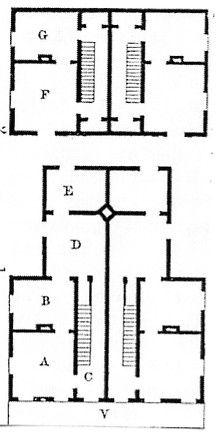
Figure 2. A typical floor plan of a two story officer's duplex. This house has a shared veranda with four rooms on the first floor and two rooms on the second floor for each family. The main floor front rooms measured approximately 15 by 15 feet. From Sheridan, Descriptions of Military Posts, 1876.
Fort Ellis (45º45'N, 110º53'W) began as a stockaded post in 1867 near Bozeman, Montana. The stockade was soon removed to prevent the impression that soldiers had to hide from Indians. Fort Ellis housed 400 soldiers and had housing for ten officers' families. The commanding officer reported in 1872 that Ellis used one of its buildings as a post library. This post, like many other western posts, provided economic support to the settlers in the area as a purchaser of both goods and labor. Though the buildings were reported to be in good condition, the intense winter cold at Fort Ellis caused the logs of the officers' quarters to snap as loudly as pistol shots. Fort Ellis closed in 1886.
Fort Harker (38º40'N, 98º10'W) was one of a string of forts in western Kansas along the Smoky Hill River. Built in 1866, Harker was a supply station for forts further west. It was a comfortable post with a post office, telegraph wire, and railroad station. It was a short four mile drive to Ellsworth for supplies. Harker housed four companies and had stone and frame quarters for thirteen officers' families. Cholera struck the post in 1867, leaving nearly fifty soldiers and more than fifty civilians dead. General Philip Sheridan moved his command headquarters to Fort Harker in 1868 to oversee the winter campaign against the Cheyenne. Harker was abandoned in 1872.
Fort Hays (38º48'30"N, 99º9'30"W) was built on Big Creek near the Smoky Hill River in 1865. A June flood in 1867 destroyed the post and killed several soldiers. Libbie Custer and her servant, Eliza, helped save several men from the flood. The post was re-built on higher ground, one-half mile from Hays City where railroad, telegraph, and postal facilities were located. Frame houses served twelve officers' families. Fort Hays was abandoned in 1889.
Fort Kearny II (40º33' N, 99º6W), the second Nebraska post named Kearny, was built on the south side of the Platte River in 1848. There it served to protect the Overland Trail and to provide supplies and other needs to the western migrants. It housed three companies. Officers' quarters were located in a single two and one-half story building with twelve rooms. Shallow wells provided water. The Union Pacific Railroad, completed in 1869, reduced travel on the Overland Trail and Fort Kearny was abandoned in 1871.
Fort Keogh (46º26'N, 105º52'W) was established along the Yellowstone River in eastern Montana in August 1876. It was quickly built as the base of supply in the campaign against the Sioux that followed the Battle of the Little Bighorn (June 1876). It served as both an infantry and cavalry post, housing as many as 800 troops at one time. Alice Baldwin described post housing as "a collection of [upright] log houses, built of not more than two rooms each." (Baldwin, p. 103) Miles City was established nearby. The post was abandoned in 1900.
Fort Laramie (42º12'38"N, 104º31'26"W) was originally a fur trade post. The US Army purchased the post in 1849 to protect migrants on the Overland Trail. Fort Laramie served as an important place for negotiations between the US Government and Indian tribes of the region. Two important treaties, The Treaty of Fort Laramie of 1851 and the Treaty of Fort Laramie of 1868 began the process of creating specific regions for occupation by Indian tribes and led to the abandonment of the Bozeman Trail in 1868. Though the post had frame and adobe quarters for officers and a schoolhouse, the buildings were considered in need of repair by the early 1870s. The fort was abandoned in 1889.
Fort Leavenworth (39º21'N, 94º 44'W) in eastern Kansas was established in 1827 to guard the Santa Fe Trail and is the oldest of the forts on the Great Plains. In the 1870s Fort Leavenworth became the Headquarters of the Department of the Missouri which supervised military activity in the Southern Great Plains. As a headquarters post, the housing was among the best on the Plains. In the 1870s two officers' quarters were built with indoor bathrooms instead of the outhouses that most quarters had. Streets were paved. Residents of the post also enjoyed a notable social life and two churches. Elizabeth Burt considered Fort Leavenworth the "land of civilization." (Burt, 119) Fort Leavenworth was made the site of a military prison in 1875.
Fort Lyon (38º5'36"N, 103º3'30"W) was the second post named Fort Lyon. The first, established near the site of Bent's Fort in 1860 on the north bank of the Arkansas River, was relocated due to flooding. Located one mile from the small village of Las Animas, Lyon had a post office, but the railroad and telegraph were located 52 miles away. It housed 320 men, and offered one and one-half story houses for twelve officers' families. Unlike most frontier posts, it also had a chapel. Alice Baldwin found a "rural scene of peace and quiet, with horses and cattle grazing in the pastures and on the adjoining prairie." (Baldwin, p. 85) Fort Lyon was abandoned in 1889.
Fort McPherson (41ºN, 100º30'W) was established in 1863 on the south side of the Platte River in Nebraska. A post of five companies, it offered a post office and telegraph wire. At this "clean little post," (Burt, p. 71), good quarters for fourteen officers were built of cedar log and cedar frame. There were no gardens at McPherson, and officers considered the land around it incapable of supporting agriculture.
Fort Phil Kearny (44º32'N, 106º52'W) was established on the Bozeman Trail in northern Wyoming Territory in 1866. Despite being located among the Sioux, Cheyenne, and Crow who contended with each other and with the US Army for control of the northern plains, the post housed several military families. It was the site of the Fetterman Fight, and the Wagon Box Fight of 1867. Though the post stood for only two years, it is important in the history of the Plains and the site of both Frances Grummond Carrington and Margaret Carrington's memoirs. The post was abandoned in 1868 according to the terms of the 1868 Treaty of Fort Laramie.
Fort Randall (43º1'N, 98º12'W) was established on the right bank of the Missouri River in 1856, part of the system of forts to protect the Overland Trail. It housed four companies, and provided housing for twelve officers and their families in cottonwood log buildings. The post was abandoned in 1892.
Fort Rice (46º41'N, 100º30'W) was built in 1864 on the right bank of the Missouri River in northern Dakota Territory. Originally comprising crude huts of cottonwood logs and sod roofs, it was considered an undesirable post eighty-five miles from a post office. Re-built in 1868, the frame two-story duplexes housed fourteen officers and their families, but were in need of repair shortly after construction. The library was used by both enlisted men and officers. The post provided quarters for four companies of soldiers. Water was drawn from the muddy Missouri River and settled in barrels before drinking. Fort Rice was abandoned in 1878.
Fort Riley (39º4'20"N, 96º43'W) was constructed in 1853 on the north bank of the Kansas River in western Kansas. By 1870, it had a telegraph wire, post office, and a station on the Kansas Pacific Railroad. It was three miles from Junction City. It housed four batteries of light artillery or eight companies of cavalry. The six duplexes for officers' families were 60 feet by 40 feet, giving each family half that space, or 1200 square feet.
Fort Robinson (42º30'N, 103º21'W) was established in 1874 in northwestern Nebraska. It also served as the headquarters for the Red Cloud Agency. In the beginning, it offered 6 small duplexes for officers and a small house for the commanding officer made of adobe with plastered ceilings. Over the years of activity, the post grew much larger and each stage of housing construction led to improvements. Fairly isolated, Fort Robinson was 170 miles from the railroad at Cheyenne, Wyoming. This post had the advantage of spring water for drinking, and by 1891 indoor plumbing was available in the Commanding Officer's quarters and some ranking officers' quarters. (Biddle, 227) Fort Robinson continued to be an active military post through World War II.
Fort Shaw (47º30'3"N, 111º40'W) was built along the Sun River in Montana Territory in 1867 near the edge of the mountains. It housed 400 soldiers and a band. Officers' quarters provided housing for 12 families in duplexes built of adobe and wood. In 1872, the commanding officer noted that all buildings were in need of repair. This post was noted for its exciting cultural life including plays and musical events or "theatricals" that were performed in a large, dirt-floored building with benches for audience seating. Fort Shaw was 83 miles from Helena, a gold mining town with several businesses, doctors, and dentists. It closed in 1890.
Camp Sheridan (42º50'N, 103º37'W) was established as a tent camp in northwestern Nebraska in 1874. It was 213 miles from Cheyenne and 160 miles from the Union Pacific railroad at Sidney. In 1875 permanent officers' quarters were constructed of board and batten (wood frame) providing housing for ten families. The commanding officer noted that efforts to raise corn, potatoes, onions, cabbage, and tomatoes had been successful. The post closed in 1880.
Fort Sidney (41ºN, 103ºW) was established as Sidney Barracks in western Nebraska in 1867. By 1872 residents had access to a post office, telegraph wire, and railroad station at the town of Sidney, one-quarter mile from the post. Two companies were stationed at Sidney Barracks, with frame, adobe-insulated, duplexes for eight officers' families. The buildings were considered to be in excellent condition. The surrounding land was considered unsuitable for farming by military authorities, so the post had few gardens.
Fort Sill (34º40'N, 98º30'W) was established in 1869 in Oklahoma (Indian Territory at the time). The first commanding officer was Colonel Benjamin Grierson. It housed six companies. Twenty officers' families lived in stone buildings. The post was located in an area where malaria threatened the soldiers' health. Fort Sill remains an active military post.
Fort Sully (44º20'N, 100º10'W) was built on the left bank of the Missouri River in central South Dakota in 1866 after the closing of the first Fort Sully. Early arrivals at the new post had to live in houses of upright cottonwood slabs which could not keep out the wind. Newer housing was comfortable and roomy.
Fort Supply (36º30'N, 99º30'W) originated as Camp Supply in Indian Territory (Oklahoma) in 1868. It became a fort in 1878. It was a stockaded fort with housing and supplies for six companies and quarters for seventeen officers. It was an isolated post with no post office, telegraph wire, or railroad station within 160 miles. Officers' quarters were built of cottonwood logs. The post was closed in 1895.
Fort Union (35º54'21"N, 104º57'15"W) was located in the northeast corner of New Mexico. Originally built in 1851, it was re-constructed in 1861, and again in 1866 with better housing for soldiers and families. It housed four companies and sixteen officers in buildings of adobe and stone. Santa Fe, 100 miles away, was the nearest city, but the post had a post office and telegraph wire for communication. Frances Boyd called Fort Union a "cheerless place," and noted that "many ladies greatly dislike Fort Union" because of the lack of trees and grass and the unceasing wind (Boyd, pp. 199-200). Fort Union was abandoned in 1891.
Fort Wallace (38º47'20"N, 101º35'W) was built in 1866 to house four companies of soldiers. The seven frame duplexes housing fourteen officers' families were in poor condition in 1871. The commanding officer noted that vegetables arrived "occasionally" from Denver. It was located two miles from the village of Wallace Station where there was a railroad, telegraph wire, and post office. Fort Wallace was abandoned in 1882.