PHYSICAL ENVIRONMENT
The Great Plains of Canada and the United States form an enormous piedmont flanking the eastern slope of the Rocky Mountains. Taken as a whole, this piedmont, some 300 to 400 miles wide and 1,800 miles long, is like a stage before the backdrop of the Rockies. Visitors have always been inclined to appreciate that backdrop more than they have the stage, but for the people who live on the Plains it remains a debatable point which of the two is really the more impressive.
Topography
Explorers often used the phrase "great plains" and even put it on maps, but the first person to recognize the Great Plains as a physiographic unit of North America appears to have been John Wesley Powell, writing in 1895. Leading geographers of the early twentieth century, such as William Morris Davis and Isaiah Bowman, picked up the term in this technical sense and soon used it in textbooks. During World War I, Nevin M. Fenneman began work on his still authoritative physiography of the United States, and his map of the physical divisions of the country, published by the U.S. Geological Survey and accompanying his text of 1931, is still in print. It demarcates not only the Great Plains, but also adds subdivisions of the Plains that have now become standard, including such colloquial ones as the High Plains and other, more technical ones such as the Plains Border and the Missouri Plateau. Edwin Hammond in 1964 proposed revisions to Fenneman's map, including dropping the term Great Plains altogether and replacing it with a set of terms including such awkward ones as Upper Missouri River Broken Lands, but Fenneman's terminology has endured.
The Great Plains slopes gently eastward. As defined here, the maximum height of its western edge rises from about 2,000 feet above sea level in Canada to more than 6,000 feet in New Mexico. On its eastern edge, the Plains drop to an elevation of about 1,000 feet along a line from Winnipeg to Kansas City, Oklahoma City, and the toe of the Balcones Escarpment in Texas. The Great Plains, therefore, slopes eastward approximately ten feet per mile, a slant that is wholly imperceptible to the unaided eye.
Most of the Great Plains, it should be stressed, is not especially flat, and this general slope can therefore be misleading. According to Edwin Hammond, the only parts of the Great Plains that are simultaneously both flat and level are the valley of the Platte River in Nebraska, the valley of the Arkansas River in central Kansas, and several former glacial lake beds, especially those now drained by the Red and Souris Rivers in North Dakota and the James River in South Dakota. There are other equally flat but not so level parts of the Great Plains: preeminent among these tilted plains are the High Plains, which extend from the Pine Ridge Escarpment in northern Nebraska south to Midland-Odessa, Texas. (Their most famous subdivision is the Llano Estacado, or Staked Plains, that extends south from the Canadian River near Amarillo and is spectacularly rimmed on the east by the Caprock Escarpment and on the west, in New Mexico, by the Mescalero Escarpment.) Tilted they may be, but to the eye the High Plains seem as level as they are flat. Indeed, they seem so level and flat that they can strike even the comfortable modern traveler as faintly distressing, for their flatness keeps the horizon always close and can create a sense of confinement. The occasional breaks in the High Plains–and there are several, including the impressive valleys of the Canadian, Cimarron, and Republican Rivers–can therefore be a welcome respite from the sense of being thrust upward and pushed into the lid of the sky. The Great Plains possesses other equally flat but tilted plains as well, but these areas are much smaller than the High Plains; economically, the most important of them is probably the wheat-rich Wichita Prairie of Kansas.
The greater part of the Plains south of the Nebraska Sandhills is composed of irregular or rolling, not flat, ground. Bounding the High Plains, for example, there are tablelands of moderate or considerable relief, both on the west near Raton, New Mexico, and on the east, with the Gypsum Plains of north-central Texas. Farther east, there are low mountains in the Wichitas near Lawton, Oklahoma; there are plains with high hills in the Lampasas Cut Plains of the dissected eastern edge of the Edwards Plateau; there are hills such as the Smoky, Flint, and Osage Hills of Kansas and Oklahoma; and there are huge areas of gently rolling plains, such as the Red River Rolling Plains of Oklahoma and Texas and the Enid Prairie of Oklahoma.
The Nebraska Sandhills, the largest area of sand dunes in the Western Hemisphere, were classified by Hammond as open hills; to their north he delineated a complex topographic mosaic including tablelands along the Missouri, open high hills in the Powder River Basin, low mountains in the Black Hills, and open high mountains in the Bearpaw Mountains south of Havre, Montana.
No classification like Hammond's has been made for the landforms of Canada, but H. S. Bostock of the Geological Survey of Canada has subdivided the Canadian Great Plains into the Alberta, Saskatchewan, and Manitoba Plains. Despite these names, the boundaries of these units follow topographical rather than political features. Thus the Alberta Plain, largest of the three, is bounded on the west by the Rocky Mountain foothills, on the north by the Alberta Plateau, which starts at the Athabaska River, and on the east by the Missouri Coteau, an escarpment that runs from near North Battleford southeasterly into the Dakotas. The Saskatchewan Plain extends eastward below the Coteau to the Manitoba Escarpment, which lies just west of Lakes Winnipegosis and Manitoba. The outstanding topographic feature on the Canadian plains, other than the subdividing escarpments, is the Cypress Hills, which rise southeast of Medicine Hat, Alberta. The Great Plains in Canada, it should again be emphasized, are by no means either entirely flat or entirely level; extensive areas here, too, are rolling or even hilly.
Strikingly, our knowledge of the topography of the Great Plains remains incomplete. This may be surprising, since the main lines of natural drainage were worked out nearly 150 years ago: those in the United States, for example, were shown in 1857 with startling accuracy on the map prepared by Lt. G. K. Warren of the U.S. Army Corps of Topographical Engineers. In the century that followed, Dominion-land surveyors in Canada and public-domain surveyors in the United States drafted planimetric maps showing almost every creek and hill on the Plains; geodetic and topographic surveyors added elevations. Yet significant details are being discovered even today. Recent digital terrain mapping by Gail Thelin and Richard Pike of the U.S. Geological Survey, for example, has revealed what appears to be an extraordinary set of regional fractures trending from northwest to southeast across the Plains, especially north of the Sandhills. Thelin and Pike suggest that these features were created by the collision and fusion of an ancestral North America with lands farther west.
Geology
As such details suggest, a real understanding of topography requires a knowledge of geology. Much sense can in fact be made of the topography of the Great Plains if we remember that the Great Plains rest upon the North American craton, which is to say the Precambrian continental core. Exposed in the United States primarily in the Superior Upland of northern Minnesota, but exposed far more extensively in the Canadian Shield, these cratonic rocks extend between the Appalachians and the Rockies. At a few places on the Plains they outcrop, most notably in the Black Hills of South Dakota, where they emerge from between encircling sedimentary layers. Less massively, they are revealed in the Little Belt Mountains south of Great Falls, Montana, and in the Wichita Mountains northwest of Lawton, Oklahoma. Elsewhere they are buried, often at tremendous depth. At Amarillo, which is 5,000 feet above sea level, the cratonic rocks lie at a depth of 3,000 feet below sea level; eastward, they plunge to a basin whose surface lies approximately 30,000 feet below sea level.
This great thickness of sedimentary rocks covering the craton accumulated over a period of several hundred million years as sediments from the Appalachians and Rockies were carried across the often submerged but intervening lowland. Periods of uplift and erosion have removed most of the sediments that at one time or another were laid down upon the craton, but, with the few exceptions mentioned above, at least some sedimentary material still remains in place atop the cratonic rocks of the Great Plains.
The surviving sections of the Tertiary, or most recent of these major sedimentary accumulations, form the floor of the High Plains. Most of even these Tertiary rocks–including the greater part of their most famous member, the Ogallala Formation–have been stripped away by erosion; as a result, the High Plains in Texas and Oklahoma break away on the east to a much older (indeed, Upper Paleozoic) sequence of sedimentary rocks. Even on the west, facing the Rockies from which the Tertiary sediments were derived, erosion has stripped away the Tertiary cover except in southeastern Wyoming, where the so-called Gangplank, near Cheyenne, provides a ramp for both the Union Pacific and Interstate 80 as they climb toward Sherman Summit. South of the Gangplank, the sedimentary rocks exposed in the Colorado Piedmont, which stretches from the Wyoming state line south nearly to Colorado Springs, are older–mostly Cretaceous–and are lower topographically, as well as stratigraphically, than the High Plains materials exposed in easternmost Colorado and in western Kansas. Cretaceous rock is exposed south of the High Plains, too, where an ancient limestone surface forms the Edwards Plateau. Still older rocks are exposed west of the Mescalero Escarpment, the western edge of the High Plains in New Mexico. North of the High Plains, sedimentary rocks of Mesozoic age form most of the surface northward into Canada, where they extend as far as the western margin of Great Bear Lake.
These Mesozoic sedimentary rocks form a surface whose irregularity may probably be ascribed, at least in part, to ancient erosion surfaces exposed when later sediments were removed, but the modern surface of the Plains owes a great deal also to repeated glaciations in the last two million years. The great Laurentide ice sheet, which blanketed all but insignificant bits of central Canada, extended southward at its maximum to about the present-day Missouri River, whose course was profoundly modified by the ice sheet and which, in Montana and the Dakotas, approximately marks the southern limit of the glacial advance.
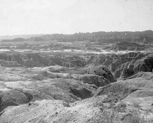
Badlands, South Dakota, ca. 1930
View largerNorth of that line, of course, there are many topographic features shaped by ice. Perhaps the most famous is the Missouri Coteau itself, a structural ridge topped with glacial sediments along its entire course from the Saskatchewan River south through the Dakotas. There are countless smaller signs of ancient ice: at Pingree, North Dakota, chains of lakes indicate former meltwater channels; drumlins (depositional hills) may be found near Priddis, Alberta; and the world's largest glacial erratics (boulders), transported 300 miles by ice, sit in huge wheat fields near Okotoks, Alberta.
The effects of the ice and of Ice Age climates are also evident, however, far south of the Missouri River, for north winds blowing over glacial outwash moved fine sand south to form great beds of loess that now cover southern Nebraska with a blanket more than thirty feet thick. (It is no longer clear that the same winds built up the Sandhills, which may have originated at an earlier time.) The loess layer thins drastically to the south, so that the High Plains at Amarillo are topped with a layer about four feet thick; the material, moreover, seems to have come from the Pecos River rather than from the north. Still, the loess of the southern High Plains may well have been transported by unusually strong winds associated with a glacial climate.
Weather and Climate
The climatology of the Great Plains is, of course, a subject in its own right, and one whose foundations go back at least to the seminal work published in 1854 by Lorin Blodget of the Smithsonian Institution. Blodget at that time published maps whose isothermal lines, joining points of equal temperature, were surprisingly accurate. His annual temperature map, for example, showed the 60º isotherm essentially as modern maps do: coming across central New Mexico, the line was draped over the Llano Estacado and continued eastward to the mouth of Chesapeake Bay. Blodget's precipitation maps accurately indicated relatively wet areas in the Northwest, in the Rockies and Appalachians, and along the Gulf Coast; significantly, they indicated a low in the Great Plains. Blodget in fact drew what we would call a twenty-inch isohyet running very close to the 100th meridian; he even correctly indicated that in the Northern Plains this line, connecting points of equal precipitation, lies slightly east of that meridian but that in the Southern Plains it crosses over to the west of it. (His map, which spoke of the "Great Plains of the Interior," made special mention of the "Desert Plains" where we now recognize the High Plains. Contrary to famous earlier assertions that this part of the country was uninhabitable by Europeans, Blodget wrote that these plains had "much capacity for cultivation.")
With all his pioneering knowledge, Blodget was keenly aware that there was much he did not understand. Things we take for granted, he advanced as tentative truths: that the atmosphere in the midlatitudes has a generally westerly flow; that the Cordilleran chains create rain shadows in their lees; that continentality induces a general decline in winter temperatures at inland locations. (Here, however, Blodget erred by attributing the decline entirely to elevation.) Of other processes much studied today Blodget had little or no conception: air mass analysis was unknown to him; so were such things as winter-storm dynamics, the role of the Rocky Mountains in nurturing the formation of the low pressure systems that contain those storms, and the role of jet streams in guiding storm movement.
The wealth of Great Plains climatological data is now so great that it is difficult to provide a coherent description of the climate of the Plains. An unorthodox but perhaps useful approach is to begin by noticing the dramatic contrast in the frost-free period as one moves northward from Texas. At San Angelo and Abilene, for example, the frost-free period is about 230 days, but as one moves north the period declines to 210 days in Amarillo; 174 days in Garden City, Kansas; 160 days in North Platte, Nebraska; 140 days in Bismarck, North Dakota; and to between 100 and 120 days in southern Alberta and Saskatchewan. The duration of snow cover naturally mirrors this disparity. North of the Black Hills, the ground is white more than three months a year, but the ground is white fewer than ten days annually south of a line drawn from Roswell, New Mexico, eastward through Plainview, Texas, Oklahoma City, and Tulsa. (It is perhaps surprising, given the duration of snow cover in the north and the added fact that snow falls in the Dakotas more than forty days a year, that total snowfall, even in the Northern Plains, is not great by continental standards: in the Dakotas, it averages about thirty-two inches. In the south, of course, accumulations are much less–hardly an inch falls annually on the Edwards Plateau.)
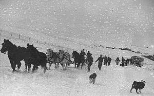
Blizzard, Allen, South Dakota, February 1946
View largerThis dramatic contrast in frost-free periods can, however, exaggerate the differences between the Northern and Southern Plains. Granted, in winter the spread between daily average temperatures in Edmonton and Amarillo is fully 30ºF, but the temperature spread between Edmonton and Amarillo in summer is only 15ºF.and the record highs in those two cities are less than 10ºF apart, which, one may be surprised to learn, is about as far apart as the highest temperatures recorded in Amarillo and scorching Midland, only 200 miles to its south. Across the entire sweep of the Plains, moreover, there are common weather elements. Everywhere, days are sunnier more often than they are cloudy: the total sunshine at Regina, for example, exceeds 2,400 hours annually, which is far higher than can be found anywhere else on the continent at that latitude. There is relatively little fog on the Plains, and average relative humidity in the summer is lower than the average relative humidity anywhere to the east. Another point in common across the sweep of the Plains. and a notorious one at that.is windiness: the flow veers seasonally from a generally northerly flow in January, especially in the Northern Plains, to a generally southerly flow in July, especially in the Southern Plains, when in particular the wind flow is exceedingly strong. The Plains are famous, too, for violent storms and sudden weather changes. In May these are classically associated with thunderstorms and–particularly in Oklahoma–with tornadoes, some fifty of which are reported annually in that state alone, where they most commonly form late in the afternoon or early evening, then ominously meander in a generally northeasterly path. In winter, the Plains are associated with cold fronts sweeping south and overnight lowering temperatures by fully 70ºF.
To this list of climatic elements that are more uniform than disparate, one finally must add precipitation, which by some measures is the most important of the lot. There can be few more arresting or compelling lines on the North American map than that of the sixteen-inch isohyet, which, like the neighboring twenty-, twenty-four-, and twenty-eightinch ones, runs almost straight from Canada to Mexico. Only at the Rockies do the well-behaved lines break up and turn into ovals that encircle highland masses.
The precipitation that falls on the Plains is well distributed for agriculture, with about 40 percent of the annual total occurring during June, July, and August, and with only about 10 percent occurring in December, January, and February. The absolute levels of precipitation on the Plains, however, were something new for settlers from the east, where equally dry climates are unknown, apart from the agriculturally useless lands of northern Canada. The consequences were tragic everywhere on the Plains but perhaps more famously in the south, where higher temperatures raise evaporative potentials to 100 inches a year or more, twice the figure at the Canadian border.
Hydrology
The proportion of Great Plains precipitation that returns directly to the atmosphere through evaporation or transpiration is amazingly great: South Dakota's Standing Rock Indian Reservation, for example, receives very slightly more than three million acre-feet of precipitation annually; of that quantity, 95 percent–2.84 million acre-feet–returns directly to the atmosphere. Runoff from the Great Plains is therefore very limited. Indeed, over most of the Plains hardly more than one inch of precipitation runs off annually, and on the High Plains and substantial parts of the Northern Plains the figure is half that. The rivers of the Plains are often reduced to trickles. Granted, these trickles can turn on a dime to raging torrents that wipe out bridges, farms, and livelihoods, but by continental standards, even the floods of the Great Plains are small things and either very local or exotic, the result of water coming from the Rockies.
Few rivers on the Plains can in fact resist the tendency to flashiness. An exception must be granted for Nebraska's Sandhills, where the branches of the Loup River are recharged by groundwater and remain remarkably constant. A more typical example, however, would be the Cimarron River near Fairview, Oklahoma. The stream carries a mean annual flow of 330 cubic feet of water per second, but 70 percent of the year its flow is less than 30 cubic feet per second, and for only a quarter of the year does its flow much exceed 200. In short, one rarely sees the stream carrying its average flow. Finding streams like these at moments of average flow can be an exercise in itself, one requiring planning: the North and South Saskatchewan Rivers, for example, peak in June or July, but their tributaries peak in April or May. At first glance this seems anomalous, but the tributaries depend on local snowmelt, while the main streams depend on runoff coming from distant mountains, where high elevations imply a later date for snowmelt.
Most of the year, a visitor to a typical Great Plains stream will be almost lost in a wide floodplain dotted with thickets of cottonwood and filled brim to brim with sand. Highway bridges that come to these valleys are impressively long, but if there are ten cantilever sections to the bridge, chances are that water is flowing under only one of them. The channel below is continually being redefined: even in periods of low flow one will hear splashes almost by the minute. Looking up in expectation of seeing an animal, instead one sees only a lonely caving sandbank and a swirl of turbidity. (Perhaps the rivers of the Plains are siltier today than they were before the arrival of farmers; in any event, the rivers of the Plains rank today as the siltiest on the continent, save only for those of the desert Southwest.)
The rivers of the Plains often mock the long blue lines on maps and disappear altogether, only reemerging miles downstream, as water gently wells up from sandy streambeds. Some portion of that stream flow, of course, percolates underground. Once there, it is by no means forgotten, however, for across the sweep of the Great Plains groundwater is a subject of the keenest interest. It has been so from the earliest period of white settlement, when the windmill became one of the chief icons of the Plains. It remains so today, when people are concerned not only for the quantity of available groundwater but also with its quality.
The most productive wells on the Plains are generally found along watercourses, but the Plains are famous for also having vast aquifers. Individual wells here may not be as productive as those in valleys, but these aquifers in aggregate yield huge quantities of water that can be extracted great distances from any substantial source of surface water. The Dakota sandstone, which takes its name from Dakota County in the northeasternmost corner of Nebraska, is a good example: indeed it is a classic case of an aquifer containing water under su.cient pressure to produce an artesian flow many miles from the point where the water sank underground.
The best known of the Plains aquifers is the Ogallala, which was named in the 1890s by N. H. Darton of the U.S. Geological Survey. Together with several smaller hydraulically connected formations that with it comprise the Great Plains Aquifer, the Ogallala covers some 177,000 square miles, across which the aquifer is draped like a blanket. Its saturated thickness varies from less than 100 feet in the southern Texas Panhandle to more than 1,000 feet in the Nebraska Sandhills. Some 22 billion acre-feet of sandy material are saturated in the Ogallala with 3 billion acre-feet of water. Twothirds of the water is in lucky Nebraska. Water enters the aquifer at a rate averaging about six inches annually, but this recharge rate depends on soil porosity and varies from almost nothing in parts of Texas to several feet annually in sandy parts of Nebraska and Kansas. (Another way of looking at this is to note that 80 percent of the total recharge occurs north of a line between Colorado Springs and Hays, Kansas.) The water in the aquifer normally moves eastward and downhill at about one foot per day. Some of it returns to rivers, which generally flow below the local water table; only a few streams–the Cimarron, for example–flow above the water table and contribute to aquifer recharge. More serious groundwater loss, however, has been suffered at the hands of farmers, particularly in the southern half of the aquifer. Willard D. Johnson of the U.S. Geological Survey warned early in the twentieth century that widespread irrigation of the High Plains was not sustainable, but his prescription of stock farming was ignored. Texas has been particularly hard hit, for it has pumped more water from the Ogallala than any other state, even though it began with only about a tenth of the aquifer's stored water. The quality of Ogallala water has changed too; wherever the reservoir underlies farmland rather than rangeland, the water has grown increasingly alkaline.
Biogeography
In the time of Lewis and Clark, such rain and snow as fell on the eastern side of the Plains supported a veritable meadow: grasses six feet high, set among deciduous trees like oak and hickory. To the west, typically at an elevation of 2,000 feet, that virgin prairie gave way to a steppe. Trees were scarce here, except for stream course cottonwoods, and the grass was short–unless one dug up the roots and found that the six inches of buffalo grass that one saw above ground capped a tangle of roots six feet deep.
By 1880, enough was known of America's vegetation for Charles S. Sargent to map America's forested regions with high accuracy. Sargent said little about the sea of grass that is the Great Plains, but he commented on the difference between bottomland forests on the eastern and western sides of the Plains: oaks, walnuts, ash, and box elders disappeared one by one, he wrote, until only cottonwoods survived beyond the 100th meridian. Like many other students, Canadian as well as American, Sargent was well aware, too, of the complex dynamics of this grassland, particularly on the eastern margin, where trees quickly invaded if fire was suppressed. The importance of fire in grassland modification, relative to soil moisture and other factors, has been the subject of debate ever since.
Twenty years after Sargent's work, which was published as a monograph accompanying the Tenth Census, C. Hart Merriam of the U.S. Biological Survey published the first map of what we today would call ecoregions. The terms he employed, such as the "austral life zone," are little used today, but the concept of an ecoregion is still indispensable. Other key ecological concepts also arose in the Great Plains in the early years of this century. The ideas of plant succession and climax communities, for example, were developed in the Great Plains by Frederick Clements, a Nebraskan by birth and training.
In 1923 Homer Shantz and Raphael Zon published their great map of the natural vegetation of the United States. The map showed a continent forested on the east but coming, as one moved westward, to an oak-hickory forest whose western margin ran from central Texas through the Ozarks to central Michigan. Immediately west of that forest in Texas, and extending to the Pecos River and the High Plains, lay a desert savanna, with mesquite, but from the southwestern corner of Oklahoma due north to Nebraska (where it curved west around the Sandhills and then resumed a northward course) lay a line marking the western edge of a tallgrass prairie, bluestems chiefly, into which the oak-hickory forest penetrated along stream courses. At an elevation of about 2,000 feet the vegetation changed to much shorter grama and buffalo grasses. Shantz, who was responsible for the part of the map showing grasslands, recognized that the line between tall and short grass is not sharp and depends in part upon soil and soil moisture conditions.
Since the 1920s, the study of Great Plains vegetation has focused in large part on getting a better understanding of the distribution of tall and short grasses and their relationship to forests. Much of this work, perhaps inevitably, has led to finer and finer subdivisions of the generalities laid out by Shantz. In 1964, for example, A. W. Kuchler prepared a map of potential natural vegetation that is widely used today and which, following Clements rather than Shantz, recognized transitional categories on either side of the tallgrass prairie. Kuchler saw the eastern part of the tallgrass as a mosaic of bluestem and oak-hickory forest, while the tallgrass prairie proper occupied only a meridional swath reaching from Winnipeg to Topeka, with arms stretching into northwest Iowa and the Nebraska Sandhills. Farther west, Kuchler recognized a bluestem prairie mixed with wheatgrass in the north and grama grass on the south; still farther west lay the shortgrass proper. Kuchler subdivided it latitudinally, with grama and buffalo grasses dominating as far north as Nebraska; to the north lay a domain of wheatgrass in the Dakotas and buffalo grass in still drier Montana.
Kuchler did not map Canada, but the same species of western wheatgrass and grama grass extend north to an encircling arc of aspen savanna, a parkland that itself grades into an aspen-spruce forest or, at the edge of the Rockies, into a spruce-pine forest. As in the United States, forest invasion of the grassland –in this case with aspen advancing by suckering rather than by seed–occurs whenever fire is suppressed, and the small amount of tallgrass prairie that once existed in the Red River Valley of the North has in this way been lost almost entirely. Although shortgrass species such as buffalo grass are now common in the driest parts of the Canadian Great Plains, their dominance appears to be the result of overgrazing in historic times. The potential natural vegetation, in other words, appears to contain taller species like western wheatgrass.
The story of plant geography in the Great Plains can hardly avoid taking notice of the arrival of farming and ranching, which has transformed the vegetation of the Plains, both to our benefit and our loss. Some introduced species are welcomed by farmers and ranchers –brome and wheatgrasses in the Northern Plains are a case in point. Others have become serious problems, among them leafy spurge in the north and prickly pear and eastern red cedar in the south. Today, as a consequence, one must hunt to locate sites where the vegetation may be even approximately virginal. Sites like the Konza Prairie near Manhattan, Kansas, thus acquire special significance.
The impact of European settlement on the animals of the Great Plains was perhaps even more dramatic. Recent research suggests that earlier accounts may have seriously overestimated bison numbers at the start of the nineteenth century and that the real number– perhaps 30 million rather than the 60 million or more often reported–may have been at a momentary and unsustainable peak. Still, the primeval bison herds beg comparison with the herbivore populations of East Africa, and their reduction to fewer than a thousand animals by 1889 is therefore all the more appalling. The pronghorn, once perhaps as numerous as the bison and yet killed off until fewer than 25,000 animals remained, supply almost as gruesome a tale of human destruction. Today, thanks to sustained efforts, the pronghorn population has risen to more than a million animals, perhaps half of them in Wyoming.
It is worth remembering, of course, that the advent of European settlement was not always so devastating. The rattlesnake is not yet endangered, despite a century or more of methodical killing. Some 250 species of grasshoppers still reside on the Plains, to which most of them are naturally restricted, and few night sounds can be as familiar on the Plains as that of the cicada. White settlement even proved a boon for some animal species, at least temporarily. The population of the greater prairie chicken, for example, exploded with the introduction of grain farming. After a peak about 1880, it began to decline with the loss of wetlands and hayfields and with competition from introduced species such as the ringnecked pheasant, a native of China. Chicken populations have recovered enough to sustain legalized hunting today in several states, particularly Kansas and Nebraska, where prairie chicken numbers may exceed those of two centuries ago.
A final point to remember is that a neatly separated discussion of plant and animal geography masks the actual and complex relationships that exist between those organisms. Much effort of late has gone into studying the effect on grassland of intensive but short-duration bison grazing. Smaller animals, too, have influenced the vegetation of the Plains. A good example is the once astronomically numerous prairie dog, which was discovered for science by Meriwether Lewis. We ourselves play not only a major but often an unconscious role in altering these several populations. The shelterbelts that were so widely planted in the 1930s, for example, are now commonly dying of old age. Farmers tend not to replant them but instead to bulldoze and grub them out. One consequence is that local populations of jackrabbits, pheasants, deer, and squirrels are losing habitat. In the absence of data, one can only wonder how many species are declining as unintended consequences of our actions.
Soils
People in an overwhelmingly urban society naturally have a hard time grasping subjects like topography and climatology or geology and biogeography, for all these things are increasingly removed from daily life. They have an almost impossible time, however, trying to muster any interest in soil and soil geography, for these are subjects inescapably linked with pejorative terms like dirt. Like all soils, however, the soils of the Great Plains reflect all the other elements of the physical environment, which can at least in large part be deduced from the crumbly or sandy, moist or dry, warm or cold soil mantle that rests on the earth.
The grass of the Great Plains, after all, is responsible for the dark color that is one of the two diagnostic traits of Great Plains soils. The other diagnostic trait of these soils arises from the climate of the Great Plains and is an alkaline layer, usually calcium carbonate, which occurs at the lowest level in the soil that is seasonally saturated. The two traits overlap. Dark color extends well east of the Great Plains, but the alkaline layer is typical of arid climates and extends well to the west. Hence the logic underlying the statement of Curtis F. Marbut, a pioneer soil scientist, that the Great Plains is simply that part of the country where these two traits overlap.
In a monograph published in 1935 as a part of the USDA's great Atlas of American Agriculture, Marbut went on to develop this idea: he pointed out that there is an inverse relationship between light soil color and deep layers of carbonate accumulation. The darkest soils, that is, are found in the wetter east, where the zone of carbonate accumulation lies at a depth of about six feet. Farther west, soil colors are lighter because there is less soil moisture and therefore less organic matter. Here, however, the zone of alkaline accumulation is much closer to the surface. On the High Plains, it is so well developed that it forms an impervious layer of so-called caliche. Marbut mapped parent material and on this basis distinguished three groups of soils based on where they were formed: glacial deposits, windborne deposits, and from bedrock–the latter lying chiefly in Kansas and the non-panhandle parts of Oklahoma and Texas. Yet when Marbut came to formally classify the soils of the Great Plains, he chose to ignore parent material and instead focus on those two diagnostic criteria we have already noted.
The eastern edge of the Great Plains thus became for Marbut the line beyond which there was enough precipitation that soil moisture percolated through the entire soil profile; there was no permanently dry zone here, and therefore no zone of carbonate accumulation. West of that line, however, one came to what Marbut, using Russian nomenclature, called the chernozems: black soils, though much thinner than the chernozems of Russia. Marbut distinguished a belt of these chernozems centered roughly along the 100th meridian from the eastern Dakotas through central Kansas, western Oklahoma, and Texas as far south as the Rio Grande. East of these chernozems generally lay forested and acidic podsols in the north and "prairie soils" to the south–soils formed under grass but so humid that the soils were degraded. West of the chernozems lay lighter-colored "dark brown" soils that graded on the west into patches of "brown" soils, which occurred in the driest parts of the Plains.
In Canada, soil taxonomists still use this nomenclature, so that most Canadian prairie soils are mapped as chernozems in the wetter and encircling savanna but dark brown and brown in the drier core along the international boundary. In the United States, however, the soil taxonomy used by Marbut was replaced in 1960 by another system, one that introduced an entire lexicon of neologisms and which is therefore exceedingly difficult for all but experts to use comfortably.
This new classification system distinguishes between Great Plains soils neither by parent material nor by color but chiefly by soil temperature and moisture. The Great Plains soils of the United States are thus now classed chiefly as mollisols, or soils formed under a cover of grasses and forbs. Subdivisions are then made on the basis of soil temperature, so that the soils of the Dakotas, where the mean annual soil temperature is below 47ºF, are recognized as borolls, while moister soils to the south are recognized generally as udolls or, in Texas, where mean annual soil temperature exceeds 72ºF, as thermic udolls. Further subdivision is made on the basis of soil moisture. East of the Missouri Coteau, for example, the soil is recognized as a udic boroll, while to the west the soil is classified as a typic boroll. Similarly, the soils of the Central Plains are divided into udolls when they have sufficient moisture for plant growth much of the year; where moisture is lacking for long periods, the soils are labeled as ustolls; where, as in southeastern Colorado, soils are usually dry and therefore low in organic matter, they are called ustic aridosols. Some soils, lacking profile horizons, are mapped instead as entisols: the most extensive areas are the Sandhills and the gray soils developed on the thin glacial debris of southeastern Montana.
It is easy for the layman to despair in the face of such verbal arcana, but there is one final point about soils that is easy to grasp. Like the groundwater and vegetation of the Plains, the soils of the Great Plains have not fared well in the last century. Estimates are that soil losses under range conditions on the Plains today average two tons per acre annually, while losses on cropland are twice that or more. The Southern and Central Plains have been hurt most, both by wind erosion on the High Plains south of the Arkansas River and by severe sheet erosion and gullying in the deep loess south of the Sandhills and in the once extensive cotton lands of Oklahoma. Nearly a century after Willard Johnson's warnings, the question of proper land use remains an open one in the Great Plains, and for all the work of the Soil Conservation Service since its creation in the 1930s, one can still drive for mile after mile across Oklahoma and see the deep and unhealed red scars etched by farmers a lifetime ago.
Significance
How, in sum, are we to comprehend this place? Keep the question simple. Forget about people. Forget about roads and railroads, wires, cables, and pipelines. Forget about towns and cities, wells for water and oil and gas, cultivated fields, and the sorry pastures that have been grazed bare by generations of cattle that have been confined behind endless miles of wretched fence lines. What are we to make of this place as God created it?
A traditional answer would have us see the Plains as a place of economic opportunity, a resource. Such an outlook kept several generations of scientists at work, supported by public funding. Another answer, however, and one more relevant to most people today, can be inferred from the overtones of the question itself. From this perspective, the Great Plains is best comprehended as a place too magnificent for fetters. Unique to the continent in always open and seemingly endless vistas, the Plains is a place to teach us how it feels to be free.
One might think back to Josiah Gregg, who in the 1830s crossed the Plains time and again between the Missouri River and the then Mexican town of Santa Fe. Gregg concluded his famous Commerce of the Prairies on an ironic note. Tongue in cheek, he wrote that the reports were accurate: the Great Plains was indeed dangerous. Gregg went on to explain, however, that the danger lay not in Indians but in the freedom of the place: like a magic elixir, the air of the Plains rendered civilized men unfit for the East–its towns full of narrow streets, its houses full of airless rooms, its people confined by girdles and neckties.
We have come a long way in taming the Plains. Perhaps Josiah Gregg was better off not having seen the fences, better off not having heard the radio stations with their incessant wheedling, better off not having smelled the feedlots that have sprung up so many places. But the Great Plains is by no means defeated. The skies remain as infinite in the day as skies elsewhere can be only at night. Muddy, modest, quietly occupied streams continue to find their lonely ways across the immensity. Grass continues to hiss before the steady wind. Geese still fly over this place; so do white pelicans en route from Great Salt Lake to the Gulf. Scissor-tailed flycatchers and roadrunners still call the Southern Plains home; other birds like meadowlarks and bobolinks, dickcissels and American kestrals are still commonplace. This is still a very physical place, huge enough that the human drama on it can shrink to insignificance. We wish to be important, influential, and so such a thought is not one we welcome. Yet there is comfort in it nonetheless, for no actor on earth could help but be thrilled by the prospect of such a huge stage.
See also WATER: Floods; Ogallala Aquifer; Rivers.
Bret Wallach University of Oklahoma
Atwood, Wallace W. The Physiographic Provinces of North America. New York: Ginn, 1940.
Bostock, H. S. "Physiographic Regions of Canada," Map 1254A of the Geological Survey of Canada, 1970.
Fenneman, Nevin M. Physiography of Western United States. New York: McGraw-Hill, 1931.
Flores, Dan. "Bison Ecology and Bison Diplomacy: The Southern Plains from 1800 to 1850." The Journal of American History 78 (1991): 465-85.
Great Plains Flora Association. Flora of the Great Plains. Lawrence: University Press of Kansas, 1986.
Hammond, Edwin. "Analysis of Properties in Land Form Geography: Application to Broad-scale Land Form Mapping." Annals, Association of American Geographers 54 (1964): 11-19.
Kuchler, August Wilhelm. Potential Natural Vegetation of the Coterminous United States. New York: American Geographical Society, 1964.
U.S. Department of Agriculture. Atlas of American Agriculture. Washington DC: Government Printing Office, 1936.
U.S. Department of Agriculture. Climate and Man. Washington, DC: Government Printing Office, 1941.
U.S. Geological Survey. The National Atlas of the United States of America. Washington DC: Government Printing Office, 1970.
Visher, Stephen Argent. Climatic Atlas of the United States. Cambridge: Harvard University Press, 1954.
Weaver, J. E. Prairie Plants and Their Environment. Lincoln: University of Nebraska Press, 1968.
XML: egp.pe.001.xml