IMAGES AND ICONS
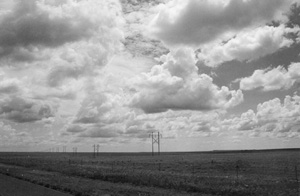
From Highway 56, near Gladstone, New Mexico
View largerPlace imagery is so much a part of everyday life that its importance and function are rarely questioned. Associations between Colorado and mountains, New Orleans and gumbo, and Vermont and quaint small towns seem at once accepted, simplistic, and trivial. Such linkages may indeed be accepted and simplistic, but their function is anything but trivial. Imagery exists, first of all, because almost any physical or cultural landscape is far too complicated to comprehend in its entirety. If we are to talk or think about such places, we are forced to generalize, to create sets of symbols that we believe embody regional essences. When applied to the Great Plains, this geographical "shorthand" includes items such as tornadoes, Frederic Remington paintings, and independent farmers.
Besides providing the generalizations necessary for ordinary conversation, place images also are strong influences on human decision making. It even can be argued that images are more important than facts in this regard. Although nearly everyone today sees the Great Plains as a rural and small-town society, for example, judgments vary on the worth of such ruralism. Some equate it with dullness, others with safety, self-reliance, and friendliness. The ratio between the two evaluations may prompt population redistributions that range between regional abandonment and congestion.
State and local agencies for development and tourism spend millions of dollars annually trying to build, modify, and counteract images for purposes of economic gain. Such efforts are hindered, though, by a scarcity of studies on what the stereotypes of various places actually are and on how the process of image creation works. The survey of Plains symbols offered here is thus more suggestive than authoritative. It draws mostly from thirty years of life in and observation of the region and stresses the views of the immigrant European American and European Canadian populations. Large-scale imagery is discussed first, and then symbols that are more geographically restricted.
Enduring Symbols
In her recent survey of Great Plains literature, Diane Quantic concluded that the most common regional symbols arise from the land itself. This finding is applicable to the entire body of Plains lore. Whether in the reports of early European visitors or in conversation with modern residents, one encounters frequent commentary on the vastness and isolation of this land, on its variable and violent weather, and on its prairie ecosystem. Part of this interest stems from an obvious contrast between the Plains environment and the landscapes of eastern Canada, the eastern United States, and western Europe. The sheer beauty, starkness, and grandeur of this physical world are even more important.
Vastness is perhaps the single most important image. Willa Cather caught the feeling well when she wrote of early Nebraska that it was "not a country at all, but the material of which countries are made." These words carry an expectation for development that has necessarily faded over time, but the grand scale of things remains. "Wide-open spaces" is the term used most frequently to verbalize this mood; the motto "Big Sky Country" that appears on Montana license plates is a close second. Grandness of scale is a concept easy to feel but difficult to crystallize into specific icons. How do you symbolize space? The most realistic depictions, perhaps, are the two largest undissected sections of the region: the High Plains in western Kansas and eastern Colorado and the Llano Estacado (Staked Plains) in western Texas and eastern New Mexico. These can be harsh and lonely places, but Plains people routinely speak of them with pride. For enthusiasts they represent solitude, freedom, and peace, the ultimate experience of open country.
If one moves beyond synecdoche, vastness also is symbolized by particulars of sky and by vertical punctuations to the omnipresence of horizontal space. A view of white cumulus clouds floating across a dome of azure blue is one common idealization, that of a towering steel gray thunderhead another. Spectacular, multiple-hued sunsets resonate still more deeply. They are among the first memorable aspects of the Plains reported by newcomers to the region and one of the sights missed most often by former residents. The use of vertical accents to emphasize a pervasive horizontality is a real-world application of a common practice in art. If the seemingly limitless expanse of the Plains cannot be captured directly by an image, use a counterpoint. The prime examples are grain elevators, windmills, and telephone poles. Elevators and windmills usually are shown standing alone and achieve their power from this starkness. Telephone poles, in contrast, typically are portrayed in groups along a road or railroad track. They convey a sense of space by directing one's eye to the vanishing point on the horizon.
The sky inevitably looms large in the landscape of any open environment. It has assumed an even more prominent role in the North American Plains because of its obvious associations with the region's highly variable, seemingly capricious, climate. Weather forecasts are given more air time on radio and television stations in the Plains than elsewhere on the continent, and with good reason. Nowhere else do strongly contrasting air masses have such potential for clashing with one another. Cold, dry polar air encounters no barrier to southward movement here except for, as the saying goes, barbed-wire fences. The same is true for dry tropical air from the American Southwest and for moister air masses from the Gulf of Mexico. Should any one of these three systems dominate for long, the product is drought, flood, or numbing cold. Should unlike masses clash, the results are some of the most vivid icons of Plains life: powerful winds, blizzards, hailstorms, thunderstorms, and, of course, tornadoes.
The role of weather icons has changed over the last century and a half. Winds that whistled through cracks in the house walls reminded many early settlers of the loneliness and harshness of their lives and broke the spirit of some. Hail was sometimes seen as the wrath of God, since it often would destroy promising crops during the peak of their summer growth. These traditional symbolic roles persist but have lessened in the face of a more diverse economy and a more sophisticated technology. Weather icons act today partly as humbling devices for residents, reminders that people do not control their entire destiny. They also are a source of self-esteem. Dakota bumper sticker messages that "–40º keeps out the riffraff" and calm Oklahoma tellings of bizarre tornado stories both imply pride in being able to cope with life in such an unpredictable environment.
Like the sky, the natural ecosystem of the Plains also has produced a set of enduring regional images. Unbroken tracts of bluestem grasses and imposing herds of buffalo and antelope were new experiences for European Americans and European Canadians during the nineteenth century and therefore celebrated. The persistence of these biological features as modern symbols is more complicated. It reflects, in part, the survival of significant areas of the natural grass cover in the Flint Hills of Kansas, in the Sandhills of Nebraska and Saskatchewan, and along the drier western edge of the entire region. The real staying power of these images, though, derives from nativeness, from their harmonious adaptation to the Plains climate. In this way they contrast with and inspire a generation of humans who have begun to see folly in their modern but unrooted lifestyles. Similar, perhaps lesser icons in this vein include cottonwood trees, coyotes, prairie dogs, pheasants, mockingbirds, and meadowlarks.
Early but Transitory Symbols
In contrast with their agreement on the importance of scale and weather to life on the Plains, nineteenth-century European Americans and European Canadians divided sharply along rural-urban lines in their assessments of economic potential. This division hinged on two powerful but opposed symbols: the desert and the garden. The garden idea appeared first when Americans in 1803 touted their newly purchased Louisiana Territory as a land of fertile soil and salubrious climate. This view was quickly overturned, though, by reports from a series of government explorers, each of whom was accustomed to well-watered landscapes. In the most widely circulated of these accounts, Edwin James wrote that the expedition of Major Stephen Long in 1820 had encountered a wasteland that extended 400 miles east of the Rocky Mountains and 500 miles north and south. It was a desolate place, he asserted, whose elevated surface was "barren desert."
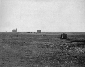
Abandoned town in western Kansas, a result of the 1890s draught
View largerResearch has shown that belief in James's conception of a "Great American Desert" was strongest in the cities of the American Northeast, especially among people there who opposed westward expansion of the nation. Rural dwellers and those closer to the frontier held the Plains in a much higher regard. This localized optimism became the general American view just after the Civil War. Actual migration to Kansas and Nebraska began on a large scale, and railroad promoters and others eager to attract settlers wrote about the landscape with unbridled enthusiasm. The Plains were now a farmer's paradise, the future garden of the world. Such imagery was as exaggerated as that of the desert had been, of course, but it persisted in the United States until the agricultural depression of the 1920s and through the 1920s in Canada. Displays of cropland bounty prepared for various fairs and expositions served as contemporary icons for this perspective. The best surviving example is the Corn Palace in Mitchell, South Dakota.
Railroads join desert and garden as important but now largely forsaken symbols of the region. As street patterns still attest, steel tracks created most Plains towns. Railroads were the primary promoters of the region, the means by which most settlers arrived, and the economic lifeline that linked local farm products with eastern markets. Like all powerful corporations they aroused mixed feelings on the part of residents, but, in the decades before the age of highways, nothing rivaled their centrality to regional life. The names of the early ones became legendary: Canadian Northern, Canadian Pacific, Great Northern, Kansas Pacific, Northern Pacific, Santa Fe, Texas and Pacific, and Union Pacific.
Early and Persistent Symbols
Perhaps the greatest drought in the recorded history of the Plains began in 1888 and lasted almost continuously until 1900. This disaster, a perversion of the garden imagery, might have prompted a return to desert thinking. Such a course of action was precluded, though, by increasing belief in new, more "scientific" methods of farming. Instead, the combination of drought and technology led to a creative, hybrid symbolization for the agricultural economy. The land still was seen to hold potential riches, but now it would yield them sporadically and only after major inputs of human effort. For Canadians the idea came to be encapsulated by the phrase "next-year country"; Americans usually spoke of a "boom-and-bust" lifestyle.
Three other enduring sets of regional images also stem from early agricultural practices: the cowboy, the yeoman farmer, and a sense of colonialism. The first two of these differ from the symbols discussed previously in that they function on the American (but not the Canadian) national stage nearly as much as they do on the regional one. The Great Plains, in fact, has become a geographical "box" into which residents of the United States have ensconced particular aspects of their perceived national character. So boxed, yeoman wholesomeness, cowboy independence, and similar rural traits can coexist peacefully with contradictory and similarly boxed national images such as the technological power and ethnic diversity associated with eastern cities.
Since the earliest days of the nation, Americans have identified themselves closely with independent farmers who live virtuous lives. The idea was written about with enthusiasm by Thomas Jefferson, encoded into the land laws by the Homestead Act of 1862, and heavily promoted for the Plains as part of the general imagery of the garden. Plains people came to see themselves as the embodiment of yeoman ideals: industrious, honest, humble, and self-reliant citizens who acquired and maintained these values by working for themselves and by being in close contact with the earth. They were living what they understood to be the American dream and were proud of it. Disparities between myth and reality, including high rates of rural tenancy and an overwhelmingly commercial orientation of the farms, were ignored. The imagery was so powerful that residents of small towns and even larger cities adopted it as their own. In this way the symbol became one with the region as a whole. Today it commonly is encapsulated by the phrase "heartland of America" and by a host of rural icons, including red barns, windmills, shocks of wheat, combines, and old pickup trucks.
Plains people allowed themselves to see only one contradiction between yeoman values and reality. Railroads, grain-marketing facilities, and banks held obvious control over their supposedly self-sufficient lives. Residents generalized these forces into an image of a New York or Toronto businessman and delivered high rhetoric on the subject during every national depression, drought, and glut of grain. The talk, in other words, was nearly continuous. Although weather certainly was not controlled by New Yorkers, and not all grain dealers were unscrupulous, having a scapegoat made Plains people feel better. It still does. Past iconography in this regard has focused on political efforts to limit monopolist power through socialistic reform. The principal symbols in Canada were the Social Credit and the Cooperative Commonwealth Federation Parties. In the United States they were the Populists and the Nonpartisan League. The New Democratic party in Canada and the conspiracy-seeking Posse Comitatus in the United States are more recent manifestations.
Cowboy imagery shares most of its basic values with yeomanry. It adds to these traits a dose of masculinity, of course, including ruggedness of character. This ruggedness supposedly comes from life on the edge of society, where nature is rawer than on a farmer's homestead; it has survived even as the nineteenth-century cowboy has evolved into the twentieth-century rancher. The invention of this virile and largely noble conception of cattle culture has been traced to the pen of Frederic Remington and his popular drawings for Harper's Monthly Magazine and Harper's Weekly between 1886 and the turn of the century. Its amazing durability as a national symbol is testimony to the values Americans place on vitality and independence. People in the Plains necessarily must share the cowboy icon with residents of the mountain West, but flatlanders feel that they have the controlling interest. Boots, hats, and longhorn steers are associated with Texas more than with any other state, and two Plains cities–Calgary and Cheyenne– host the biggest rodeos on the continent.
More Recent Symbols
The yeoman farmer and the cowboy together served as master symbols for the Great Plains from the beginnings of European American and European Canadian settlement until about 1960. A desire to maintain the selfconception of an independent, hard-working, and honest society was great enough to sustain this imagery through the challenges of major droughts in the 1890s and the 1930s, numerous periods of low prices, and steadily mounting evidence that market forces were far more international than local in scope. Plains residents even clung to the symbols for a while in the face of growing national fascination with gleaming new factories and cities. These old ideals continue as a part of regional identity, but they are faded and must confront a competing set of images.
The countersymbol to the noble yeoman farmer is the hick. On the Plains the transition from the former image to the latter has important roots in the photographs of rural failure made during the years of the Dust Bowl by Dorothea Lange and Arthur Rothstein. Wartime concerns kept this new interpretation of Plains life from capturing the public imagination for a decade or so, but then came the unprecedented rewards of continuing prosperity and modern technology. Urbanized Canada and the United States became synonymous with sprawling suburban houses, leisure time, health insurance, and television. Migration from farm to city increased rapidly, and a contrast between city and hinterland became evident. Rural areas, to urban eyes, now appeared as cultural backwaters; their formerly noble inhabitants looked dull and unsophisticated.
The view that the American Plains no longer was the progressive, vital heartland of the nation grew in the 1960s and 1970s. Outside writers saw the people as conservative and the towns as safe but dull. They labeled the region as a whole "flyover country," implying a culturally barren landscape that must be endured on travels from the modern cities on one coast to those on the other.
Few studies have explored how Plains residents have reacted to the new set of uncomplimentary images. Clearly, though, local people see and understand the implications of out-migration from their counties. They know the mindsets of the vacationers who pass through on their way to somewhere else. Given a choice of places to live in the 1970s, college students from North Dakota said they would opt for Minnesota over their home state. Those from Kansas selected Colorado. Such nonlocal patterns of preference are rare outside the Plains and suggest that regional pride may be weaker here than elsewhere. Some writers even make a case for a collective inferiority complex.
Student polling notwithstanding, it is obvious that pride is far from extinct on the Plains. Recent evidence includes a massive wave of moral outrage that broke across the region in the early 1990s over a seemingly innocent proposal by Frank and Deborah Popper of Rutgers University. These scholars noted the local population declines and suggested a planned approach to its management rather than laissez-faire. Instead of eliciting yawns, however, their vision of a publicly owned "buffalo commons" in the heart of the Plains hit a raw nerve. Local newspapers and speeches have been filled with rebuttals ever since. The Poppers, they say, have badly underestimated Plains grit. As for the phrase "buffalo commons," it has become iconographic: uttered often and always with venom.
Many of the most positive expressions of regional pride in recent decades have been tied to sport. An admiration of physical vigor, once tested by muscular jobs on farm and railroad, underlies this alliance. Professional teams in the region command good followings, but the core of loyalty is more local: high school and university teams in the United States and the junior leagues in Canada. The sport of choice varies across the states and provinces as a reflection of history, climate, and winning tradition. It is football in Nebraska, Oklahoma, and Texas; basketball in Kansas; hockey in the Dakotas and the Prairie Provinces; and rodeo along the western borderland. Nebraskans who wear red university sweatshirts can easily extend the positive feelings associated with Cornhusker football to themselves and to their state; the affection even may carry over to the Plains as a whole.
Evidence exists that Plains residents finally are beginning to see their land more on its own terms and less as a stage for acting out the expectations of others. One sign is a renewed interest taken in regional history. Detailed maps of the Chisholm, Oregon, Santa Fe, and other pioneer trails are in demand. County historical societies thrive, and visitors stream to restorations of nineteenth-century forts, cattle towns, sod houses, and the childhood homes of such place-oriented writers as Willa Cather, Wallace Stegner, and Laura Ingalls Wilder. These activities reflect more than a desire to connect with the past. In a manner similar to that adopted for tornado stories, they also celebrate a people's ability to survive and to prosper in a potentially dangerous environment.
The most direct evidence for a society becoming one with a place may be their acknowledgment and appreciation of an environmental aesthetic. This, too, is becoming more common for Plains people. When strangers are not around, they sometimes will talk about their love for the prairie and its big sky. They do so even though the Plains world lacks mountain ridges, seashores, and the other common cues for beauty. Their emotion is a complex response to the absence of things, to the power of space and solitude. With few material "things" to focus upon, egos begin to melt away. Some call the experience prairie Zen.
The Prairie Provinces
The isolation that is central to any discussion of the Great Plains is doubly applicable to its Canadian section. The Prairie Provinces are squeezed north and south between the border of the United States and the boreal forest; the high Rockies isolate them from Vancouver. More important historically, 1,300 miles of the agriculturally barren Canadian Shield separate Winnipeg from the industrial cities of southern Ontario. People in the Prairie Provinces feel that the national power brokers from Montreal, Toronto, and Ottawa discount their views and goals and see them as secondclass citizens. Consequently, their identity has come to be symbolized largely through a series of individuals who have protested against the eastern hegemony.
Louis Riel, after more than a century of mixed evaluation, has emerged as the most important hero of the Prairie Provinces. Two rebellions carry his name, in 1869–70 and in 1885, both aimed at protecting the rights of local people (the Métis) against invaders from the East (Anglo-Canadians). Although government forces technically won both protests, the Métis gained recognition for their preexisting land claims, first in the Red River Valley of the North and then in Saskatchewan. Gabriel Dumont, Riel's military commander during the second rebellion, also has become increasingly admired by modern residents; the site of his defeat at Batoche, Saskatchewan, is visited frequently.
Following the period of major European Canadian settlement from the 1880s to World War I, protests against the eastern establishment began to emanate from all Prairie peoples, not just the Métis. Residents believed that they paid more in taxes to Ottawa than they got back in services. They favored trade reciprocity with the United States but could not prevail over the protectionist national policies of the industrialists in Toronto and Montreal. Such matters came to a symbolic head in 1919 with the Winnipeg General Strike. Demands for old-age pensions and unemployment relief voiced there served as the inspiration, some fifteen years later, for Canada's first socialist party, the Cooperative Commonwealth Federation (CCF).
Depression in the 1930s cemented the budding association between the Prairie Provinces and socialistic politics. An Alberta form, the Social Credit Party, was promoted by radio evangelist William Aberhart. The Saskatchewan equivalent was the ccf. Both won and kept control of their respective provincial governments. Longtime CCF leader T. C. "Tommy" Douglas gained a major national presence as well and sponsored the first public medical insurance plan in North America. CCF influence continues today under the label of the New Democratic Party.
The European Canadian settlement of the Prairie Provinces was promoted even heavier than was the equivalent process in the United States. Physical conditions were rather different, too, with a climate that allowed crop agriculture to exist all the way westward to the Rocky Mountain front (except for southern Alberta). This physical potential for farming gave rise to two enduring descriptive terms: the "Last Best West" and the "fertile belt." Symbolic credit for the successful colonization, however, has been accorded to a particular seed and a particular man. The seed is Red Fife wheat, a variety that matured ten to twenty days faster than did previous wheats and thus ensured reliable yields. The man is Clifford Sifton, a minister of the interior who boldly expanded the recruitment field for Prairie settlers from the United Kingdom alone to the United States, Germany, and eastern Europe. Sifton essentially created the current social and ethnic geography of the region, a rich mosaic that includes the Russian pacifists known as Doukhobors and a huge contingent of Ukrainians. This blend frightened British Canadians at the time, but it since has come to be a proud badge of Prairie regional identity, a Canadian "mosaic." More recent Prairie symbols relate mostly to the achievements of individuals. John Diefenbaker, known for patriotic rhetoric during his tenure as prime minister, is revered today primarily for being the first national leader to have true Prairie roots. Two heroes share the regional hockey glory. Gordie Howe, a former leader in career points for the National Hockey League, was born in Floral, Saskatchewan. Wayne Gretzky, the current career leader in points, achieved his fame with the Edmonton Oilers.
Although outsiders easily lump the Prairie Provinces together, their residents see clear, province-based images. People in Saskatchewan, the most rural of the three units, regularly endure the label of hick. Albertans also are separated out easily. Their grasslands south of Calgary provide a strong cowboy theme. Their oil fields are rich enough to prompt both an increasing devotion to conservative politics and an occasional characterization as "blue-eyed Arabs." The new Reform Party, with an agenda to cut social programs, is based in Calgary.
The Central and Northern Plains States
The imagery associated with the northern half of the American Plains differs only moderately from regionwide generalities. The most distinctive contrasts relate to a relative abundance of broken or hilly terrain. Another set stems from an unusual ethnic mix in the Dakotas. The influence of the rougher landscape is complex but begins with visual distinctiveness. The Flint Hills of Kansas are modest in size but still the most recognized physical division in the state. Nebraska's Sandhills, stretching more than 250 miles east and west, are even more spectacular, and nearly the entire terrain of the Dakotas west and south of the Missouri River varies between moderately dissected and an otherworldly maze of erosion known as the Badlands. True mountain clusters exist as well, several in central Montana and the dramatic Black Hills in western South Dakota.
Almost all these broken lands retain their native covers of grass or forest and are used as pasture for livestock. Stockman images thus are strong, with Wyoming often said to be more dependent on cattle than any other state. Rougher land also has added a growing image of recreation potential to several locations. People drive Nebraska 2 and Kansas 177 to explore the serenity of the Sandhills and the Flint Hills, respectively. They are awestruck by the national parks in both the North Dakota and the South Dakota Badlands, and they can pursue a wide diversity of leisure activities in the Black Hills. Mount Rushmore is a national icon. The regional recreation image also encompasses a series of major reservoirs on the upper Missouri River. Fort Peck Lake has dominated the Montana Plains since the early 1940s. Downstream are the "Great Lakes of the Dakotas": Sakakawea, Oahe, Francis Case, and Lewis and Clark.
The symbolic designation of the western Dakotas and eastern Montana as an important part of America's "Indian Country" is still another terrain-related feature. The major Native peoples concentrated there (the Arikaras, Assiniboines, Chippewas, Crows, Gros Ventres, Hidatsas, Mandans, Northern Cheyennes, and especially the Lakotas [or Sioux]) were Plains dwellers at the onset of European American immigration. Their concentration in these rougher lands, though, was mainly a matter of coercion. Icons abound. The Little Bighorn Battlefield National Monument is on the Crow Reservation in Montana, and the grave of Sitting Bull is on the Standing Rock Reservation in North Dakota. The small settlement of Wounded Knee, South Dakota, is symbolic as the site both of a brutal massacre a century ago and of a major protest against federal Indian policy in 1973. Nearby, in the Black Hills, an immense and still unfinished statue of Crazy Horse also serves a dual symbolic role: for a growing racial tolerance in the nation and for an enduring Lakota claim to these mountains as a spiritual center.
Together, the presence of badlands topography, a strong ranching tradition, some 30,000 Native Americans, and mountain scenery in the Black Hills has given South Dakota a positive statewide image that is at least as much western as it is midwestern. This identity contrasts sharply with that of states to its north and south and is one that tourist officials play to regularly and with success. In a recent ranking of "favorite tourist destinations," for example, South Dakota was the only state in the Plains tier to escape the bottom grouping.
North Dakota's image is nearly as distinctive as that of its neighbor to the south but not nearly as marketable. Ethnicity is its focus, in particular, the influx a century ago of some 125,000 Norwegians and 117,000 Russians of German ancestry. Together, these peoples were the core of a foreign stock that constituted an astonishing 71 percent of the state population in 1910. The early Norwegians and German Russians were wary of one another but shared a deep respect for physical work, for farming as a way of life, and for religion. These traits have come to be central to the North Dakota image. The two peoples also were receptive to socialist politics as a means to counter the local influence of eastern capitalists. Their Nonpartisan League, which flourished from 1915 to 1921, has become a major source of state pride. It is honored today through its legacy of government-owned banks and grain elevators.
Nebraska and Kansas lack the ethnic and physical variety of the Dakotas. American settlers in both states came principally from the old Northwest Territory and became known for their close identity with the imagery of garden and yeoman. The special local strength of such belief may derive from timing. This central section of the Plains was occupied earlier than either the Dakotas or West Texas, before droughts and other problems had diminished enthusiasm. Belief also has been augmented by the fact that two of the most powerful writers on Plains agrarianism–Willa Cather and Mari Sandoz–came from Nebraska.
Beyond Cather's fictional characters of Ántonia Cuzak and Alexandra Bergson, the major symbol of pride and identification in the Nebraska Plains is the Sandhills, a magnificent ranching region that occupies most of the north-central portion of the state. The grass there is good, and the people are secure and self-confident. The region typifies pastoralism at its best. Nebraskans also derive satisfaction from their stewardship of the Platte Valley. Whether via the Union Pacific Railroad or Interstate 80, this was and is the most heavily trafficked pathway across the Plains. A list of individual Nebraskans of heroic status would include politicians William Jennings Bryan and George Norris, both champions of public interest legislation, and Tom Osborne, leader of the "Big Red" football dynasty.
The brand of agrarianism found in Kansas long had a puritanical flavor. This self-righteous spirit originated with the territorial victory of free-state forces over slavery ones (symbolized by activist John Brown) and evolved into similar crusades for prohibition (Carry Nation) and other progressive ideas. So long as the nation honored its small-town roots, Kansans felt good about themselves, and they joined their fellow Americans in making Dwight Eisenhower and editor William Allen White into icons of their period. Pride turned into defensiveness, however, when it became clear that most of the nation no longer admired rural virtue. Residents still rankle at every showing of the movie version of The Wizard of Oz, easily the most powerful image for the state. In it Kansas is a dull, black-and-white place, far different from the alluring world of Oz. Recent decades have brought more positive thinking back to the state. People tout the corridor of cities along the Kansas River from Manhattan to Kansas City for its blend of sophistication, friendliness, and relatively low cost of living. They show pride in rural roots by transplanting to suburban yards an old standby from the north-central counties: limestone fence posts.
The Southern Plains States
Americans regularly draw a distinction between the Central and Southern Plains at the Kansas-Oklahoma border. The assumption is that Kansans are descendants of a homogeneous immigration from Ohio, Indiana, and Illinois, whereas Oklahomans and Texans represent a mosaic of southerners, Native Americans, and Hispanics. Anyone who believes this and travels through the Panhandle region expecting to encounter a world limited to Baptist and Catholic churches, Native American settlements, and Garth Brooks songs will be disappointed. The local imagery is complicated.
The actual divide in western Oklahoma between settlers of midwestern ancestry and those from the South is near the east-westrunning Canadian River. In Texas it is near the Prairie Dog Fork of the Red River even farther south. This pattern was initiated during a series of land rushes that opened most of Oklahoma Territory to European American occupation between 1889 and 1901. Midwesterners, who had lined up on the Kansas border, garnered control of half the acreage before they met the Texans coming north. Life in northwestern Oklahoma and the Texas Panhandle thus differs considerably from that depicted by the images dominant in the rest of their respective states. The limit of midwestern settlement corresponds with wheat as a dominant crop. The same line traditionally marked the southern limit of Republican politics. Amarillo, with its rail connections to Kansas City, and Lubbock, with its major cotton market, nicely symbolize the two orientations.
The older cultural imprint from population origins in the Southern Plains gradually has eroded in the face of more powerful, statebased associations. This is the force that, for outsiders, has repositioned the modern Plains divide at the Kansas-Oklahoma border. Simple examples are the license plates and the stylized tipi designs at roadside rest areas in Oklahoma; both proclaim the state to be Native America. The "Okie" image of Anglo-Oklahoma, drawn originally from the southeastern section of the state, is even more strongly established. This unflattering symbol of rural poverty is far different from that of a Kansas yeoman farmer.
Statewide imagery for Texas, without doubt the most powerful in the nation, emphasizes the perspective of European American settlers and their cattle. By overstating the role of the Plains in state history, this distortion flatters West Texans. Unfortunately, it also misrepresents the true Plains heritage. The contributions of early midwesterners and more recent Hispanics disappear. So do the irrigated cotton fields south of Lubbock and the large herds of sheep and goats kept alongside the cattle on the Edwards Plateau.
The role of cattle culture in the symbolism of the Southern Plains is difficult to overstate. The lawns of the capitol in Austin and Oklahoma City are both graced by statues of cowboys. The mascot of the University of Texas is a longhorn steer, and Oklahoma is home to separate halls of fame for rodeo and cowboys. On an individual level, the most famous Oklahoman remains cowboy humorist philosopher Will Rogers. And J. Frank Dobie's collected stories of ranch life find a place on nearly every Texas bookshelf.
After cattle, the major images for the region come from the experiences of the Dust Bowl, the oil industry, and football. The Dust Bowl affected all the Great Plains, of course, but because devastation was the worst in the Panhandle area, the stories focus here. These narratives, mostly about hardships and abandonments, effectively ended popular associations between the Southern Plains and yeoman agriculture. The resultant perceptual void well could have been filled by emphasis on the increasingly elaborate irrigation systems of the time, but outsiders, at least, chose to acknowledge only ranching.
Oil and football play related symbolic roles. Their heroes, whether roustabouts, fullbacks, or wildcatters, are males known for physical stamina and courage, not intellectual prowess; they continue the stereotypical mind-set of the cowboy. Regional football attention at the university level focuses on Texas Tech in Lubbock. Oil imagery is concentrated in two locations: the Panhandle field between Amarillo and Kansas and the West Texas field that encompasses Midland and Odessa, Texas, and Hobbs, New Mexico.
Coda
Once established, regional images can take on lives of their own. Most travelers to the Great Plains will have heard about wheat in Saskatchewan or Anglo ranchers in Texas before they actually experience either of these places. With the images firmly in place, these visitors then will look for (if only subconsciously) and almost surely find evidence to support the stereotypes. Just as surely, they may ignore the presence of flax next to the wheat or of a Hispanic irrigation worker beside the rancher. Stereotypes, then, although necessary, can limit our ability to see the Great Plains afresh and for what it really is. We need to know the imagery better so as not to be limited by it.
See also film: The Wizard of Oz / LITERARY TRADITIONS: Cather, Willa; Sandoz, Mari / PHYSICAL ENVIRONMENT: Dust Bowl; Llano Estacado; Sandhills / POLITICS AND GOVERNMENT: Diefenbaker, John; Eisenhower, Dwight D. / PROTEST AND DISSENT: Nonpartisan League; Riel, Louis.
James R. Shortridge University of Kansas
Allen, John L. "The Garden-Desert Continuum: Competing Views of the Great Plains in the Nineteenth Century." Great Plains Quarterly 5 (1985): 207-20. Avellanet, John R. "Landscape Symbols and Their Role in Establishing Sense of Place: A Case Study of Kansas." Master's thesis, University of Kansas, 1995. Averill, Thomas F. "Oz and Kansas Culture." Kansas History: A Journal of the Central Plains 12 (1989): 2-12. Bader, Robert S. Hayseeds, Moralizers, and Methodists: The Twentieth-Century Image of Kansas. Lawrence: University Press of Kansas, 1988. Broach, Elise L. "Angels, Architecture, and Erosion: The Dakota Badlands as Cultural Symbol." North Dakota History 59 (1992): 2-15. De Wit, Cary W. "Sense of Place on the Kansas High Plains." Master's thesis, University of Kansas, 1992. Emmons, David M. Garden in the Grasslands: Boomer Literature of the Central Great Plains. Lincoln: University of Nebraska Press, 1971. Evernden, Neil. "Beauty and Nothingness: Prairie as Failed Resource." Landscape 27 (1983): 1-8. Jordan, Terry G. "The Anglo-Texan Homeland." Journal of Cultural Geography 13 (1993): 75-86. Logan, Linda. "The Geographical Imagination of Frederic Remington: The Invention of the Cowboy West." Journal of Historical Geography 18 (1992): 75-90. Matthews, Anne. Where the Buffalo Roam: The Storm over the Revolutionary Plan to Restore America's Great Plains. New York: Grove Weidenfeld, 1992. McLaird, James D. "From Bib Overalls to Cowboy Boots: East River/West River Differences in South Dakota." South Dakota History 19 (1989): 455-91. Mc-Murtry, Larry. In a Narrow Grave: Essays on Texas. New York: Simon and Schuster, 1968. Quantic, Diane D. The Nature of the Place: A Study of Great Plains Fiction. Lincoln: University of Nebraska Press, 1995. Rees, Ronald. New and Naked Land: Making the Prairies Home. Saskatoon: Western Producer Prairie Books, 1988. Shortridge, James R. The Middle West: Its Meaning in American Culture. Lawrence: University Press of Kansas, 1989. Stein, Howard F., and Robert F. Hill, eds. The Culture of Oklahoma. Norman: University of Oklahoma Press, 1993. Wallach, Bret. "Oklahoma: When the Jokes Wear Thin." Focus 42 (1992): 32-37. Wilkins, Wynona H. "The Idea of North Dakota." North Dakota Quarterly 39 (1971): 5-28.Previous: | Contents | Next: Billy the Kid
XML: egp.ii.001.xml